Hurricane Ian – Post-Event Update

Summary:

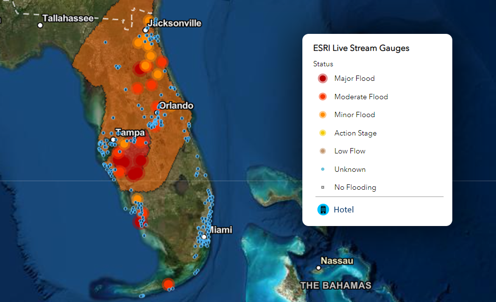
The 2022 hurricane season was quieter than the average of the previous 10 years, with nine named storms to date (vs last 10 years’ average of 17).

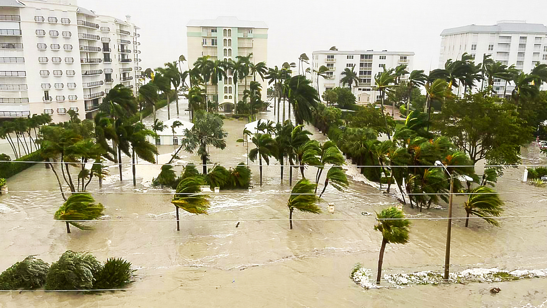
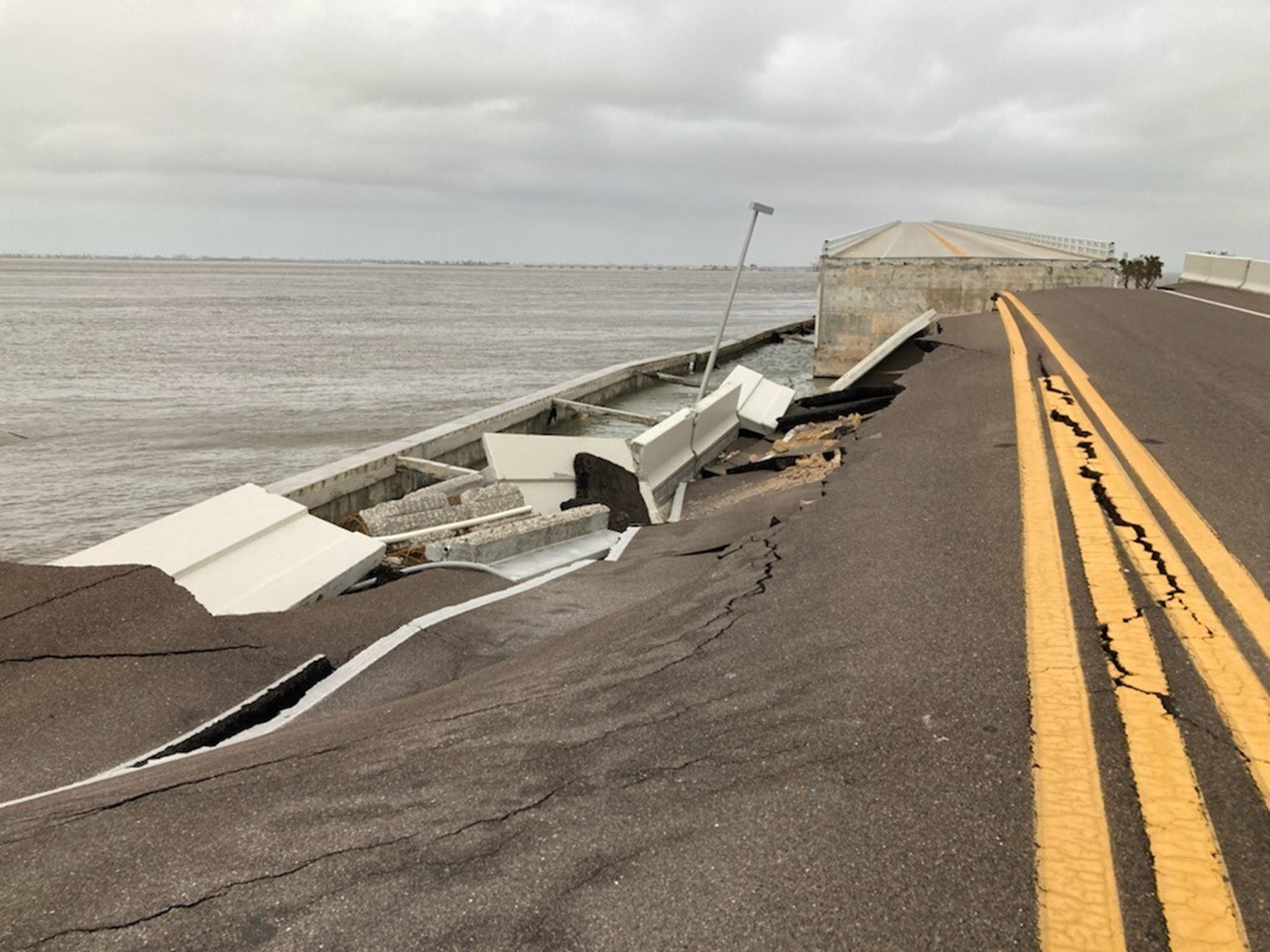
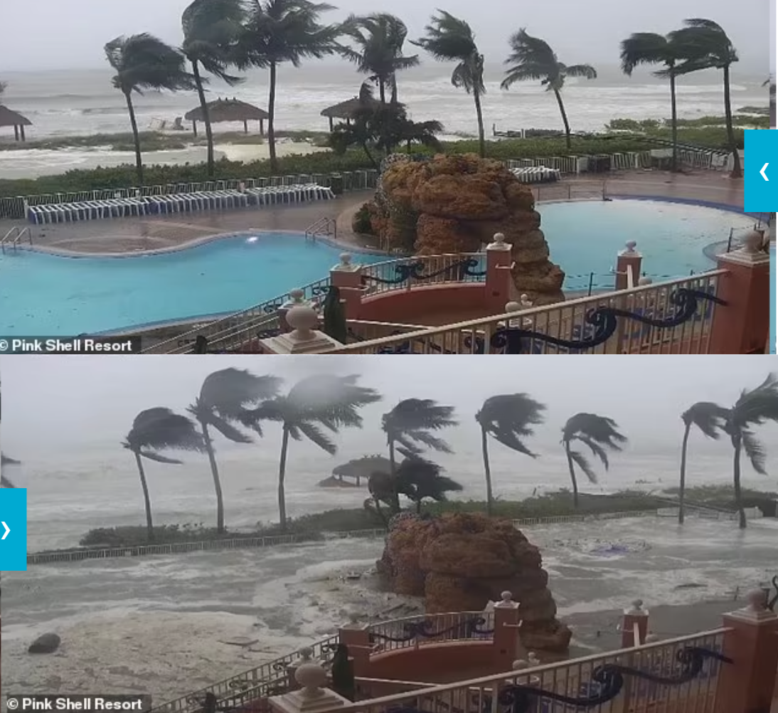
Ian is the ninth named storm, the fourth hurricane, and the second major hurricane of the 2022 season, and has intensified after entering the Gulf of Mexico on September 27th, 2022, after making landfall in Cuba. Subsequently, Hurricane Ian made landfall in the USA, on 28th September, at 15:00 Local Time, near Cayo Costa in Florida, as a Category 4 Hurricane, with wind speeds reaching 155 mph.

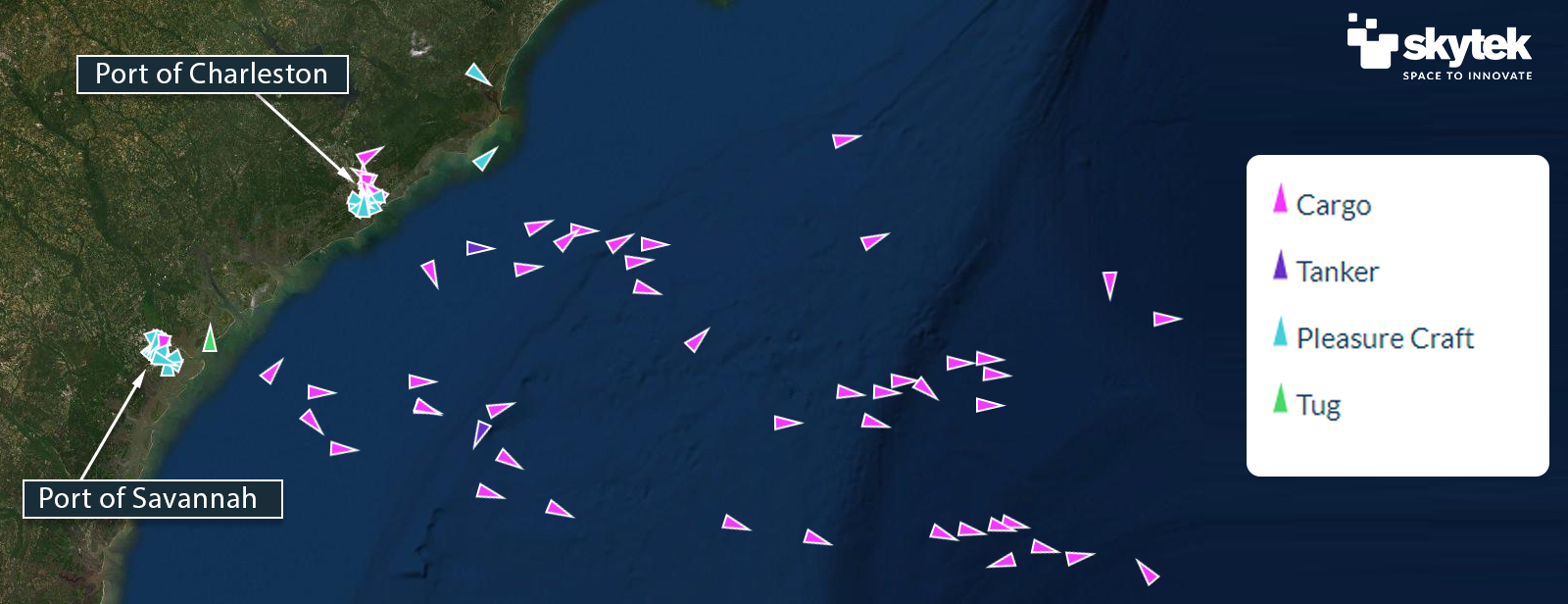
The latest advisory information issued at 12UTC on Thursday, September 29th, states that winds slowed to 75 mph, downgrading the storm to Category 1 status. Storm Ian is currently moving toward the northeast and with some turns expected later today and Friday, which predict the centre of the storm to move off the east-central coast of Florida soon and then approach the coast of South Carolina on Friday. The centre will move farther inland across the Carolinas Friday night and Saturday, with winds not expected to exceed 40 mph.

The risk of Storm Ian strengthening before hitting the Carolinas and causing further substantial devastation is still present.

POWER DISRUPTION

Hurricane’s Ian powerful landfall resulted in significant damage to the infrastructure on the ground. The power outage in the Florida peninsula left more than 2.4 million people without power. The entire County of Charlotte was left in the dark as of Thursday morning. The Florida Power & Light Co. stated in a tweet on Wednesday night, that Ian’s catastrophic winds meant parts of its system would “need to be rebuilt — not restored”, as it warned residents to be “prepared for widespread, extended outages”.


The map in Figure 1 below provides a scale of the power outages situation as of Thursday morning:

Figure 1: Scale of the Power Outages in Florida, following Hurricane Ian's landfall.

PORTS AND OFFSHORE DISRUPTIONS

Skytek is monitoring the marine assets and the ports in the path of Hurricane Ian. As detailed in the Pre-Event report, there are three main ports in the area directly affected by the hurricane. As of Thursday morning, these ports have not reported significant damage, with updated information for each port available below.

Using the REACT system, Skytek provides a representation of the cargo vessels steaming out of the hurricane’s path, as well as the vessels currently in the area – The situation as of 10:00 UTC time is provided in Figure 2 below, when Skytek detected 22 commercial vessels in the Hurricane Cone, all steaming away, with an estimated value of $1 Billion.

Figure 2: Vessels present in the two active ports in the area as well as steaming out of them at 10:00 UTC.

Port Tampa Bay has been coordinating closely this week with federal, state and local agencies, as well as the maritime community, in order to prepare for and respond to the potentially devastating impact of Hurricane Ian. These actions resulted in Hurricane Ian having minimum impact and causing minimum damage. As of Thursday morning, there are no vessels queuing to enter the port. The port is expected to reopen in the next days;

The Port of Charleston will be closed starting September 30th, as stated by a port spokesperson. One cargo vessel is currently in the port of Charleston and is expected to depart before port closure tomorrow.

Port of Savannah had cleared all the cargo vessels in preparation for the passage of Hurricane Ian. 13 yachts and two Passenger Riverboats remained in the port and are expected to stay. Hurricane Ian hasn’t reached this port yet.

YACHT AND PLEASURE BOAT DAMAGE

In the aftermath of Hurricane Ian, Skytek’s REACT platform detected 22 high-value yachts that stopped transmitting any data for more than 12 hrs, at the time of this report release. Skytek will continue monitoring the situation, as these figures could significantly change over time.


Skytek will employ very high-resolution Earth Observation and aerial imagery, to provide in-depth and up-to-date information about the status of the assets within the affected marinas in the area, as well as the condition of the infrastructure around them. Data will be available as soon as technically and safely possible.


One of the marinas actively monitored by Skytek, Gasparilla Marina in Boca Grande, has suffered significant damage, as shown by the pictures available in the media (Figure 3). This marina has been acquired by very high-resolution satellite in the weeks prior to the damage (Figure 4). This satellite image will be used as a reference to provide detailed information about damage post-hurricane.

Figure 3: Gasparilla Marina, Boca Grande – Credits: @JenHemmerdinger, @VirginiaJohnson - Twitter.
Figure 4: Gasparilla Marina, Boca Grande, from satellite, August 2022 - Photo ©2022 Planet Labs Inc. All Rights Reserved.

PROPERTY AND INFRASTRUCTURE DAMAGE

In the initial aftermath of Hurricane Ian’s landfall, the most significant damage appears to be to properties, due to the storm surge flooding as well as the high velocity winds. The sections below provide an initial update on the areas mostly affected by such damage.

Using Earth Observation data from satellites and aerial imagery, Skytek will provide up-to-date information about the status of the properties and the infrastructure within the areas directly affected by the hurricane. Data will be available as soon as technically and safely possible.

The flood chart below provides flooding status information updated as of Thursday morning, using measurements of water levels provided by local stations. The concentration of luxury hotels within the flooded area is provided in Figure 5 below:

Figure 5: Flooding status on Thursday morning, overlayed with luxury hotel’s locations.

FORT MYERS AND SURROUNDING AREAS

Prior to slowing down and being downgraded into a Category 1 storm, Hurricane Ian resulted in devastating effects in the Fort Myers area, where it made landfall on Wednesday with 150 mph winds, almost the strength of a Category 5 hurricane.

Pictured from the media show a severely flooded Fort Myers, as shown in Figure 6 below. A satellite image overview of the area has been acquired on September 23rd (Figure 7) and will be used by Skytek to provide accurate information about the level of damage as soon as post-event imagery will be available.

Figure 7: Overview of Fort Meyers from satellite on 23rd September 2022 - Photo ©2022 Planet Labs Inc. All Rights Reserved.
Figure 6: Fort Myers area on Wednesday – Credits @Meteor_Mike - Twitter

The Sanibel Causeway in San Carlos Bay, Southwest Florida, is the only connection available between Sanibel Island and the Florida mainland. A section of one of the three bridges this is composed of, has collapsed on Wednesday due to the passing of Hurricane Ian, as shown in Figure 8 below. The structure will have to be rebuilt.

Figure 8: Section of Sanibel Causeway wiped off by Hurricane Ian - Credits @Fox4Now.

A local hospital (HCA Florida Fawcett Hospital) is reported in the media as significantly damaged as the storm surge flooded its lower-level emergency room while fierce winds tore part of its fourth-floor roof from its intensive care unit.


Several hotels in Fort Myers and surrounding areas are reported severely flooded and damaged by the strong winds, as shown in Figure 10 below, for the Pink Shell Resort in Fort Myers.

Figure 10: Pink Shell Resort hotel CCTV images showing destruction from Hurricane Ian - Credits @ Pink Shell Resort.

THEME PARKS

No damages are reported to the main theme parks in the area, as the hurricane passed south of these resorts.

However, the parks will remain closed until Friday.

AIRPORTS

A number of airports were impacted by the devastation caused by Hurricane Ian. Even if not directly damaged by the high-speed winds and flooding, most airports in the area had significant disruptions in their operations: Southwest Florida International Airport, Orlando International Airport and Jacksonville International Airport ceased operation and cancelled over 3000 flights.

Significant damage is reported in the media for North Perry Airport and Sarasota Bradenton International Airport, spanning from partial roof damage to several small planes flipped upside down (Figure 11) and damaged hangars due to several tornadoes that spawned by the outer rain bands of Hurricane Ian.

Figure 11: Damage at North Perry Airport - Credits @TotalTrafficMIA – Twitter

Putting Earth Observation & Satellite Technology in the Hands of the Insurer

EO satellite image providers:

Disclaimer

The content in this report is provided for general information only. It is not intended to amount to advice on which any reliance should be placed. Skytek advises that professional or specialist advice is obtained before taking, or refraining from, any action on the basis of this report.

The contents of this report is provided in good faith but Skytek make no representations, warranties or guarantees, whether express or implied, that the contents of this report is accurate, complete or up to date.

To the extent permitted by law, Skytek will not be liable for any loss or damage, whether in contract, tort (including negligence), breach of statutory duty, or otherwise, even if foreseeable, arising under or in connection with use or reliance on any content of this report. In particular, Skytek will not be liable for any loss of profits, sales, business or revenue, business interruption, loss of anticipated savings, loss of business opportunity, goodwill or reputation or any indirect or consequential loss or damage whatsoever or howsoever caused.

Login