Hurricane Ida

The ninth named storm, the fourth hurricane, and the second major hurricane of the 2021 hurricane season, Ida, has explosively intensified after entering the Gulf of Mexico on August 27th.

Ida came ashore 16 years to the day after Hurricane Katrina and made landfall Sunday south of New Orleans.

Hurricane Ida doubled in less than 24 hrs from 70 mph winds to 150 mph winds and landed near Port Fourchon as a Category 4 hurricane.

The entire city of New Orleans lost power after all eight transmission lines were knocked out — even one that withstood Katrina.

The following subsections provide an overview of the damage brought by the hurricane.

Power outages in New Orleans

Power Disruption

The power outage in New Orleans heightened the city’s vulnerability to flooding and left hundreds of thousands of people without air conditioning and refrigeration in the sweltering summer heat.

The entire city of New Orleans late Sunday, August 29th was without power, according to city officials. The city’s power supplier — Entergy — confirmed that the only power in the city was coming from generators, the city’s Office of Homeland Security & Emergency Preparedness said on Twitter. The message included a screenshot that cited “catastrophic transmission damage” for the power failure.

The city relies on Entergy for backup power for the pumps that remove stormwater from city streets. Rain from Ida is expected to test that pump system.

More than 1 million customers were without power in Louisiana, and over 40,000were in the dark in Mississippi, according to PowerOutage.US, which tracks outages nationwide.

Ports & Offshore Oil & Gas Pipeline Operation Disruption

Hurricane Ida disrupted ports operations in the area. The U.S. Coast Guard reports that the ports of Lake Charles and Cameron in Louisiana, and Biloxi and Pascagoula in Mississippi, reopened Tuesday, August 31st to vessel traffic. The Louisiana Offshore Oil Port (LOOP), reported in an initial assessment, that there was no significant damage; however, it remains closed for the time being.

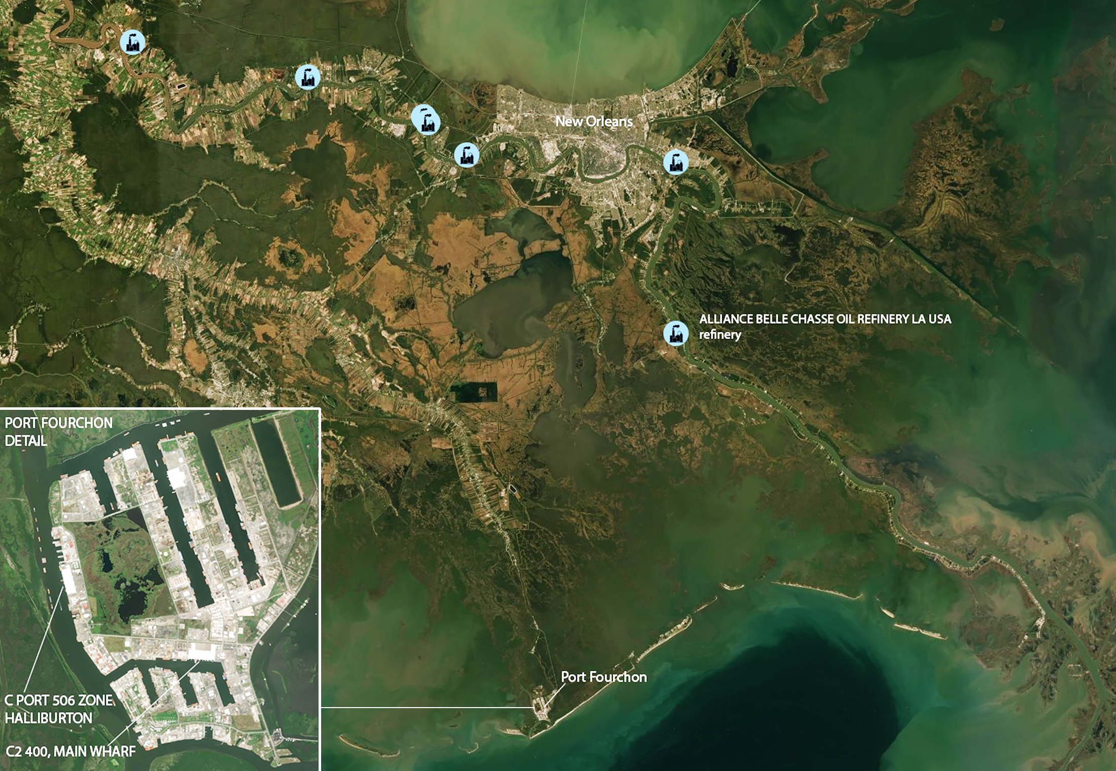
The Louisiana ports of Baton Rouge, New Orleans, Plaquemines, South Louisiana, St. Bernard, Venice, Houma, Morgan City, Port Fourchon, and the South West Pass Lightering Area remain shut to vessel traffic.

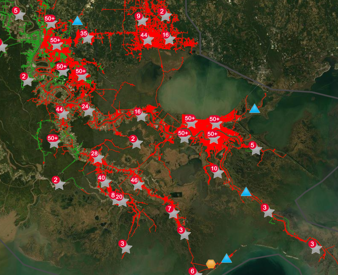
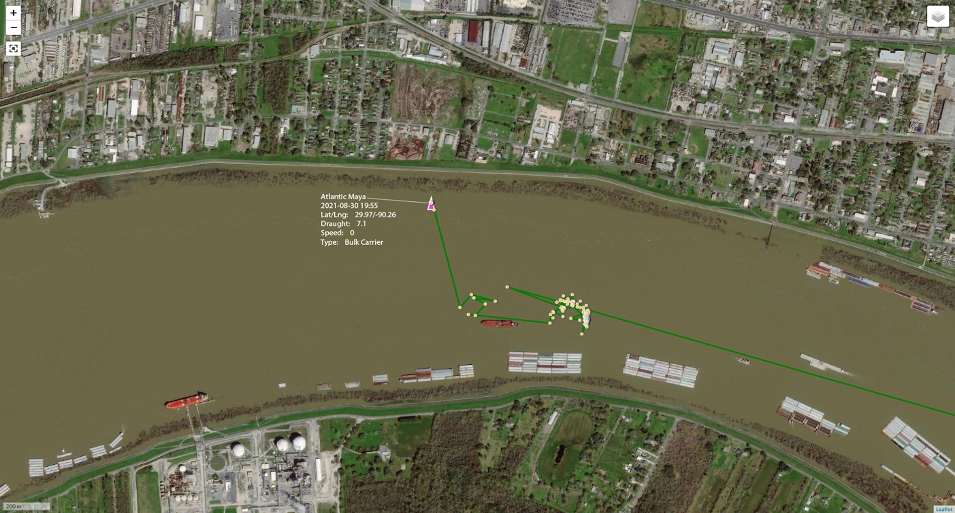
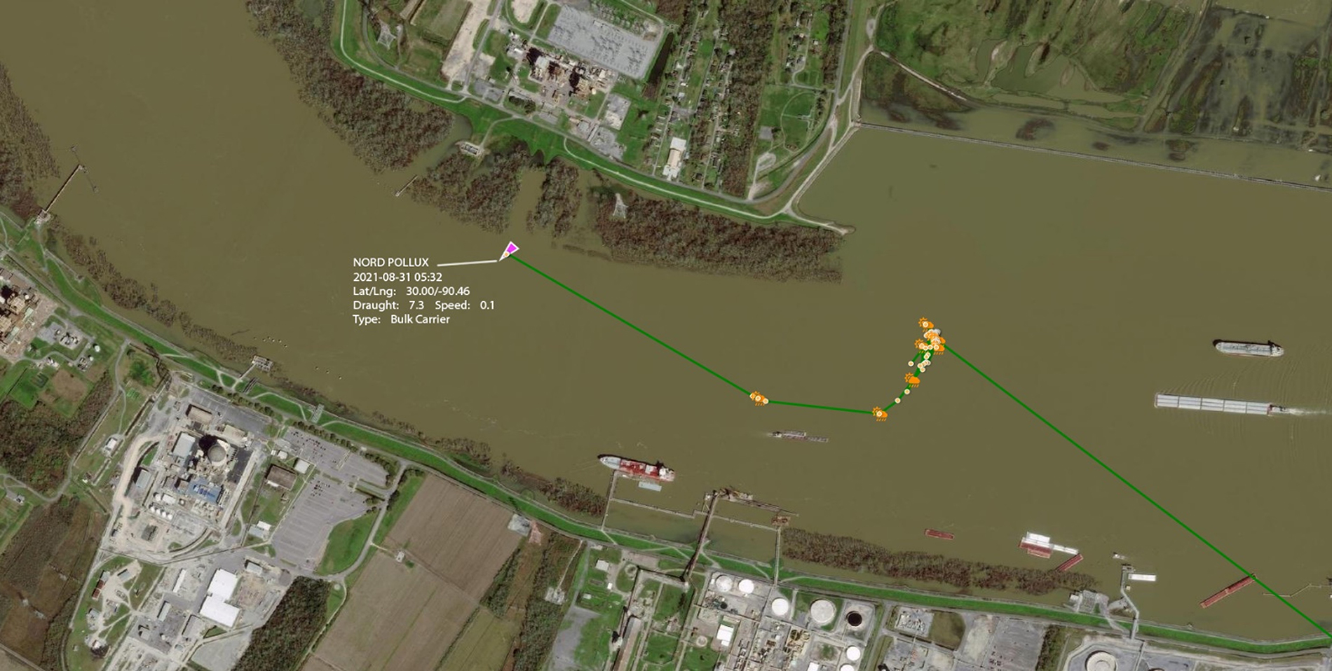
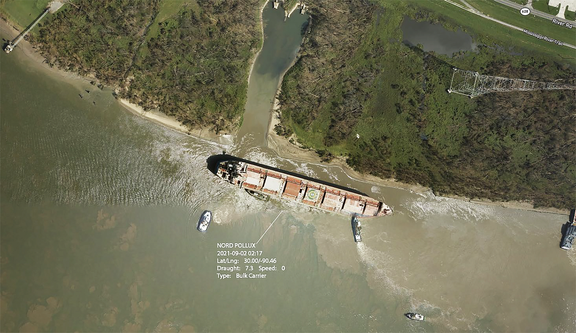
Thirty-two tankers and bulk carriers are waiting at Southwest Pass for the USCG reopening of the ports in Baton Rouge and New Orleans.

The BSEE (Bureau of Safety and Environmental Enforcement) advised that most of the U.S. Gulf of Mexico offshore oil and gas output were halted due to the storm, with 94% of oil and natural gas production still suspended on Tuesday, August 31st.

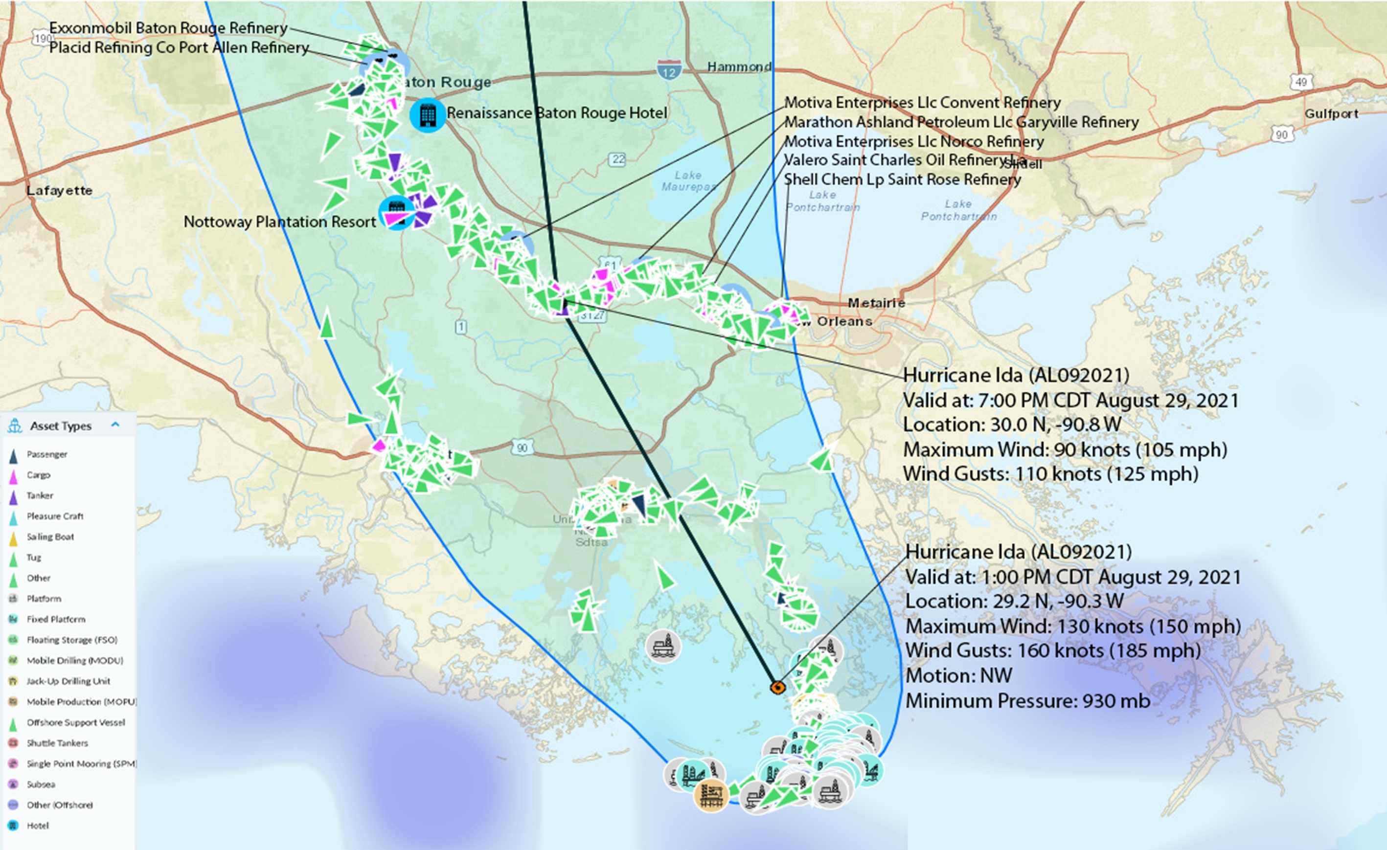
Offshore oil and gas pipelines that feed processing plants remain primarily shut. However, the Colonial Pipeline, the largest fuel line to the East Coast, restarted operation on Monday after being shut down before the storm. Exxon Mobil’s Baton Rouge complex is expected to resume operation shortly.

Figure 1: Vessels waiting at Southwest Pass for the USCG reopening of Baton Rouge and New Orleans ports.

Onshore Storage, Production & Refineries Damages

Figure 2: Pre and Post-hurricane satellite and drone images of storage tanks in Port Fourchon

Figure 3: Pre and Post-hurricane satellite and drone images of storage areas in Port Fourchon

Figure 4: An AHTS (anchor handling tug supply) vessel swept ashore in the Port Fourchon area on a floating dock.

Ida moved slowly inland, bringing heavy rains, which resulted in flooding. Through UAV/drone imagery, Skytek can report that the isolation dams around the storage tanks in Phillips 66 Refinery Alliance – Belle Chasse are flooded and not operational following a levee collapse. It may require several days for the water processing plant in the refinery to drain the floods and allow the refinery to resume normal operations. The extent of the flooding can be seen in the images below.

Figure 5: The location of Alliance Belle Chasse Oil Refinery

Figure 6: Pre and Post-hurricane satellite and drone images of Phillips 66 Refinery Alliance – Belle Chasse.

Figure 7: Pre and Post-hurricane satellite and drone images of Phillips 66 Refinery Alliance – Belle Chasse.

Update**

After the hurricane, the refinery valued at $1,3 billion was put up for sale. A buyer was not found and it was subsequently converted into a storage facility. The latest satellite image taken on 24th May 2022 shows all floating roof tanks down, meaning most tanks are empty. The refinery/storage plant has not been in use since 2020.
Sateliite image of Phillips 66 Refinery Alliance - Belle Chasse. Taken 24th May 2022.

Property Damage

Ida brought 150 mph force winds, a storm surge of 12-16 feet, and excessive rain, which destroyed many properties in the cities south of New Orleans.

Houma–Terrebonne Airport was in the trajectory of the hurricane, and the extent of the damage it suffered can be seen in the images below:

Figure 7 – Pre and Post-hurricane satellite and drone images of Houma –Terrebonne airport

Laffite area: residential buildings, three schools, and local administration buildings are captured in the images below. The facilities are completely flooded from the storm surge and excessive rains. and local administration buildings are captured in the images below. The facilities are completely flooded from the storm surge and excessive rains.

Figure 8 – Pre and Post-hurricane satellite and drone images of Laffite area.

Crown Point: residential buildings and local stores have sustained wind damages and are surrounded by water from the excessive rains, as depicted below:

Figure 9: Pre and Post-hurricane satellite and drone images of Crown Point area.

Golden Meadow: Hurricane Ida swept over residential buildings with destructive force in this area of Louisiana, as can be seen in the images below.

Figure 10: Pre and Post-hurricane satellite and drone images of the Golden Meadow area.

Marine Hull Damage

Of 135 blue water ships captured on August 26th from Port Fourchon to Baton Rouge, 56 sailed away before August 30th. The remaining 77 blue water ships were primarily Bulk Carriers.

Figure 11: REACT view of the exposure at Hurricane Ida landfall, August 29th.

The REACT system during the hurricane registered 60 vessels anchored on the Mississippi; few appear to have run aground. These include the Nord Pollux – IMO: 9728174, Atlantic Maya – IMO: 9303003, Ubc Tampico – IMO: 9285354, LT Ocean Star – IMO: 9328560, Derby – IMO: 9464780; as seen in the post-event imagery below.

Figure 12 - Atlantic Maya runs aground on August 30th.
Figure 13 - Nord Pollux runs aground on August 30th.
Figure 14 - Nord Pollux runs aground on August 30th.

EO satellite image providers:

Disclaimer

The content in this report is provided for general information only. It is not intended to amount to advice on which any reliance should be placed. Skytek advises that professional or specialist advice is obtained before taking, or refraining from, any action on the basis of this report.

The contents of this report is provided in good faith but Skytek make no representations, warranties or guarantees, whether express or implied, that the contents of this report is accurate, complete or up to date.

To the extent permitted by law, Skytek will not be liable for any loss or damage, whether in contract, tort (including negligence), breach of statutory duty, or otherwise, even if foreseeable, arising under or in connection with use or reliance on any content of this report. In particular, Skytek will not be liable for any loss of profits, sales, business or revenue, business interruption, loss of anticipated savings, loss of business opportunity, goodwill or reputation or any indirect or consequential loss or damage whatsoever or howsoever caused.

Login